FEBRUARY 2021
Tour an expansive collection of beautiful, innovative maps:https://mapgallery.esri.com/?adumkts=social&utm_source=social&aduc=social&adum=external&aduca=social_technical&adusf=linkedin&adut=371cf967-b2fe-4530-be1a-32bd1e7afcb6
A Location Suitability Analysis. Electric Vehicle Charging Stations: https://mapgallery.esri.com/map-detail/5b34122532aa4a6b3479206f
Director of the Climate Center at Texas Tech University Professor Kathrine Ann Hayhoe Speaks About Climate Change: https://www.esri.com/content/dam/esrisites/en-us/about/news-room/podcasts/climatechangeishereandnow.mp3
How to Change the Way We Talk about Climate Change: https://www.esri.com/about/newsroom/arcuser/change-discussion-on-climate-change/
JANUARY 2021
GIS DAY 2020 at Aglantzia's High School: Η ΕΚΔΗΛΩΣΗ ΠΟΥ ΓΙΟΡΤΑΣΤΗΚΕ ΣΤΟ ΓΥΜΝΑΣΙΟ ΑΓΛΑΝΤΖΙΑΣ ΓΙΑ ΤΗΝ ΠΑΓΚΟΣΜΙΑ ΗΜΕΡΑ ΓΕΩΓΡΑΦΙΚΩΝ ΣΥΣΤΗΜΑΤΩΝ ΠΛΗΡΟΦΟΡΙΩΝ / GIS DAY 2020: VIDEO
These seed-firing drones plant thousands of trees each day: https://www.linkedin.com/posts/world-economic-forum_these-seed-firing-drones-plant-thousands-activity-6737758016826855424-e8S1
DECEMBER 2020
Η ΣΥΓΧΡΟΝΗ ΓΕΩΓΡΑΦΙΑ ΤΩΝ ΕΠΙΔΗΜΙΩΝ: https://www.linkedin.com/posts/christina-karouzi-4a915935_%CE%B7-%CF%83%CF%8D%CE%B3%CF%87%CF%81%CE%BF%CE%BD%CE%B7-%CE%B3%CE%B5%CF%89%CE%B3%CF%81%CE%B1%CF%86%CE%AF%CE%B1-%CF%84%CF%89%CE%BD-%CE%B5%CF%80%CE%B9%CE%B4%CE%B7%CE%BC%CE%B9%CF%8E%CE%BD-selas-activity-6736195291726311424-EhgM
REMOTE SENSING - ΤΗΛΕΠΙΣΚΟΠΗΣΗ: https://education.maps.arcgis.com/home/webmap/viewer.html?webmap=0ee186c87ce34543b656a625bf42f28f
REMOTE SENSING - ACTIVITY: https://www.esri.com/content/dam/esrisites/en-us/media/pdf/geoinquiries/earth-science/2-remote-sensing-earthscience-geoinquiry.pdf
NOVEMBER 2020
ΕΚΘΕΣΗ ΚΑΘΗΓΗΤΗ ΓΙΩΡΓΟΥ ΣΕΚΚΕ ΓΙΑ ΤΗΝ ΗΜΕΡΑ ΤΩΝ ΓΕΩΓΡΑΦΙΚΩΝ ΣΥΣΤΗΜΑΤΩΝ ΠΛΗΡΟΦΟΡΙΩΝ
DISCOVERING, INNOVATION & HOPE: https://storymaps.arcgis.com/stories/652993f26b064461a31e5befdb3d47f3
FINDING AMAZING STORIES THROUGH GIS: https://storymaps.arcgis.com/stories/a8591f1541df4846832e19dd1aabfebe
OCTOBER 2020
Μόνιμη Κυπριακή Επιτροπή Τυποποίησης Γεωγραφικών Ονομάτων ΜΚΕΤΓΟ: http://www.geonoma.gov.cy/index.php/epitropi/synthesi-epitropis
Χάρτες της Κύπρου: http://www.geonoma.gov.cy/index.php/chartes
Μόνιμη Κυπριακή Επιτροπή Τυποποίησης Γεωγραφικών Ονομάτων ΜΚΕΤΓΟ: http://www.geonoma.gov.cy/index.php
SEPTEMBER 2020
GIS IN A TIME OF COVID: https://www.youtube.com/watch?v=42eFnLZ6bXM&feature=youtu.be
AUGUST 2020:
Learn More About The History Of Woodstock: https://mail.aol.com/webmail-std/en-us/DisplayMessage?ws_popup=true&ws_suite=true
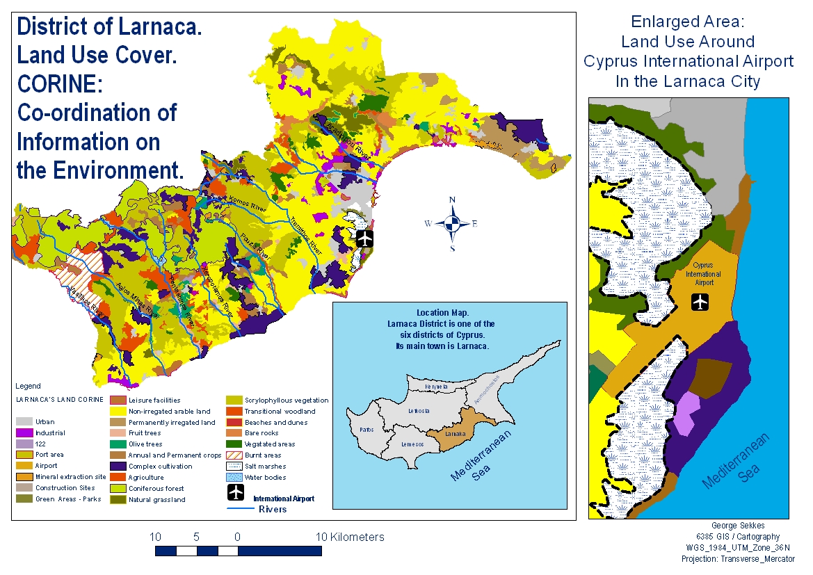
CYPRUS INTERNATIONAL AIRPORT - MAP
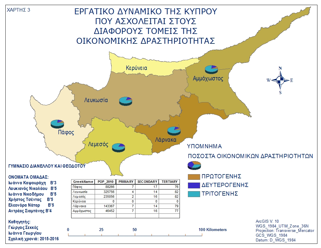
CYPRUS ECONOMIC ACTIVITIES - MAP
JULY 2020:
The Global Goals for Sustainable Development:
GIS. Enabling a smarter world: https://www.youtube.com/watch?time_continue=32&v=_qSenzfSwvA&feature=emb_logo
JUNE 2020:
ESRI'S USER CONFERENCE: https://www.esri.com/en-us/about/events/uc/overview
ΓΕΩΓΡΑΦΙΚΗ ΚΡΟΥΑΖΙΕΡΑ: ΓΕΩΓΡΑΦΙΚΗ ΚΡΟΥΑΖΙΕΡΑ 2020 ΔΗΛΩΣΗ ΣΥΜΜΕΤΟΧΗΣ
Sustainability. Enabling a Smarter World: https://www.esri.com/en-us/solutions/industries/sustainability/overview
MAY 2020:
Τρόοδος και εγένετο Κύπρος: https://www.youtube.com/watch?v=HRqR9mGyUEQ
Troodos and the birth of Cyprus: https://www.youtube.com/watch?v=QNiSIUmW33w
APRIL 2020:
Geographical Information Systems GIS. Explore the lesson library. An Implementation guide for Teachers, Schools, and Districts: https://learn.arcgis.com/en/educators/
The first documentary movie about the origin of Wuhan Coronavirus: https://www.youtube.com/watch?v=3bXWGxhd7ic
Στην Κοπεγχάγη, της Δανίας ολοκληρώθηκε η "καθαρότερη
μονάδα παραγωγής ηλεκτρικής ενέργειας από απόβλητα στον κόσμο."
Όχι
μόνο είναι ο καθαρότερος χώρος αποθήκευσης ενέργειας σε όλο τον κόσμο, είναι
επίσης ο τόπος ενός ανθρωπογενούς βουνού που ονομάζεται CopenHill επίσης γνωστό
και ως "Amager Bakke", που
έχει τη δική του πλαγιά που χρησιμοποιείται δημόσια για σκι, με μονοπάτια για
πεζοπορία και ορειβασία που λειτουργεί όλο το χρόνο.
March 2020:
COVID-19 Overview. Understand, prepare for, and respond to COVID-19 in your community or organization: https://coronavirus-resources.esri.com/
Ανταρκτική-Γροιλανδία: Οι πάγοι λιώνουν με εξαπλάσια ταχύτητα από ό,τι το 1990:
Ελλάδα: Με
εξαφάνιση κινδυνεύουν παραλίες
:
Πλοήγηση σε χάρτες της Κύπρου: https://eservices.dls.moi.gov.cy/#/national/geoportalmapviewer
Νέα διαδικτυακή πλατφόρμα του τμήματος κτηματολογίου και χωρομετρίας: https://portal.dls.moi.gov.cy/el-gr/homepage/pages/default.aspx
February 2020:
Πλοήγηση σε χάρτες της Κύπρου: https://eservices.dls.moi.gov.cy/#/national/geoportalmapviewer
January 2020:
Why GIS In Education Matters: https://www.geospatialworld.net/blogs/why-gis-in-education-matters/
10 interesting and lesser-known facts about GPS: https://www.geospatialworld.net/videos/10-facts-about-gps/
December 2019:
November 2019:
ΓΙΩΡΓΟΣ ΣΕΚΚΕΣ: Παγκόσμια Ημέρα Γεωγραφικών Συστημάτων Πληροφοριών / GIS
October 2019:
NATIONAL GEOGRAPHIC. A film that everyone must view about the Island of CYPRUS: https://youtu.be/MKlq4gQKtU0
Winter is just about to begin:
https://www.facebook.com/SotisHAgaphEinaiMakria/videos/490831424753264?s=750486774&v=e&sfns=mo
September 2019:
Πλατφόρμα ArcGIS για μαθητές/τριες:http://gis4greekschools.maps.arcgis.com/home/index.html
How do tornadoes form: https://www.triviagenius.com/how-do-tornadoes-form/
Interactive 3D Map of the Moon:https://www.linkedin.com/feed/update/urn:li:activity:6558332363066220544
Soil absorbs and stores carbon from the atmosphere.
Can it help mitigate climate change:
https://www.facebook.com/natgeo/videos/10153685617108951?s=750486774&v=e&sfns=mo
August 2019:
Woodstock‘s upcoming 50th anniversary. The Bethel Woods Center for the Arts announced that a three-day event will take place on August 16th-18th in 2019, and will be held at the same location where the original Woodstock Music & Arts Festival took place back on August 15th-17th, 1969: https://liveforlivemusic.com/news/woodstock-50-anniversary-bethel-woods/#.XCZVefOxvjt.mailto
Urban Planning GIS Exercises. Nicosia: https://www.gislounge.com/free-urban-planning-gis-exercises/
This amazing and rare wave
formation is called a tidal bore.
https://www.facebook.com/ScienceNaturePage/videos/744975328968061?s=750486774&v=e&sfns=mo
July 2019:
ΠΛΑΤΦΟΡΜΑ ArcGIS ΓΙΑ ΣΧΟΛΕΙΑ: http://gis4greekschools.maps.arcgis.com/home/index.htm
Στις Θαλασσινές Σπηλιές της Πέγειας ανεγείρονται παραθεριστικές κατοικίες σε απόσταση μόλις 30 μέτρων από τη θάλασσα, μεταξύ των δύο σημαντικότερων σπηλιών αναπαραγωγής της μεσογειακής φώκιας http://www.philenews.com/f-me-apopsi/arthra-apo-f/article/660435/den-lifthike-ypopsi-to-aftonoito
January 2019:
GIS in Sustainable Urban Planning and Management. Example: Nicosia, Cyprus how public places can facilitate social interactions: https://www.itc.nl/urbangis/chapter-7/
GIS in Sustainable Urban Planning and Management: A Global Perspective: https://www.itc.nl/urbangis/chapter-7/md-nicosia.pdf